|
|
|
|
Front

| Languages: French and English |
| Dimensions: 1000mm x 705mm x 1mm |
| Map Scale: 1:1,000,000 |
| Legal Deposit: No. 53, 4eme trimestre 2003 |
| Print Run: 500 copies |
|
| Item Identification Code (UID#): 702 |
| Shelving Location: Maps: large format |
| Estimated Value: £5.00 |
| Purchase Date: 21 December 2004 |
| Purchased From: Log In to view this |
|
Fianarantsoa
Carte Internationale du Monde
|
[International World Map]
|
Foiben-Taosarintanin'i Madagasikara (FTM) (2003). (First Published 1965)
|
|
Rolled Sheet
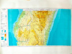
The third of four large maps collectively covering the entire island of Madagascar at a scale of 1:1,000,000. Based on maps compiled in 1965 this edition was partially revised in 2003.
|
Notes
|
|
|
Condition of Item
|
|
Very good.
Refer to the glossary for definitions of terms used to describe the condition of items.
|
Categories
|
|
|
|
BUY FROM AMAZON.COM
Browse 100s More Titles in our Madagascar Book Store
|
Photographs of the Item (Total: 1)
|
Click image to see larger:
 |
|
|
|
|
| Front |
|
|
|
|
|
|
© 2006–2025 Daniel Austin
|